
Paleoearthquake and Hydroclimatic Records
from Lake Tahoe and the Salton Sea, CA
By:
Danny Brothers
Postdoc
U.S. Geological Survey (USGS)
When: |
Friday, April 9, 2010, 10:30 a.m. to 11:30 a.m. |
Where: |
Seminar Conference Room, 10100 Burnet Road, Bldg 196-ROC, Austin, Texas 78758 |
Hosts: |
Gail Christeson, UTIG |
LIVE BROADCAST: TBA
Ongoing studies in the Lake Tahoe Basin (LTB) and Salton Sea are aimed at understanding earthquake history across submerged and active faults. In the LTB, a suite of marine geophysical data (sub-bottom CHIRP, sidescan sonar and multibeam bathymetry) and piston cores were used to define the timing and magnitude of the most recent earthquake on the West Tahoe Fault. Field surveys revealed an ancillary, but fascinating discovery. A group of submerged, upright trees were imaged acoustically, sampled and radiocarbon dated to ~1250 AD. Dendrochronology performed on wood samples and water balance calculations suggest the LTB experienced severe, multicentennial drought during medieval times. Similar methods were applied in the Salton Sea, California, where the San Andreas Fault (SAF) terminates and transfers strain across a series of short, extensional faults to the Imperial Fault. The southernmost SAF has not ruptured in over 300 years and is considered �overdue� for a large-magnitude earthquake.
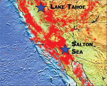
Earthquake epicenters from USGS Earthquake search page.
To understand the hazards in the region, we collected >1,000 line-km of seismic CHIRP profiles in the Salton Sea to define the sedimentary and earthquake history along the submerged faults. Observations suggest faults in the Salton Sea can potentially generate M6-6.6 earthquakes every 150 years or so, which, in turn, may modulate the state of stress on the southern SAF. Furthermore, the stratigraphic coincidence of fault displacement and deposition of delta facies indicates that some ruptures were synchronous with Colorado River floods into the basin. Flooding increases both the vertical load and pore pressure on faults making them more inclined to fail.


