
Revealing Hidden Deformation Sources in New Zealand:
A Novel Inversion of GPS Data
for Non-prescriptive Physics-based Surface Forces
and High Precision Strain Rates
By:
Lada Dimitrova
UTIG
| When: | Wednesday, May 15, 2013, Noon to 1:00 p.m. |
| Where: | Seminar Conference Room, 10100 Burnet Road, Bldg 196-ROC, Austin, Texas 78758 |
Abstract
The devastating earthquake sequence that began in late 2010 in Christchurch, New Zealand occurred on previously unknown faults. Such hidden faults are one example of subsurface sources driving surface deformation. Other subsurface sources include faults locked at depth, e.g., the Alpine fault which is thought to produce Mw=8 earthquakes, and deep magma reservoirs, such as those in the Taupo Volcanic Zone in the central North Island.
In some cases, these sources can be difficult to detect due to a lack of clear surface expression. Analysis of GPS velocities has potential to uncover active subsurface sources; however, current methods are limited because GPS velocities are a broad wavelength response to subsurface sources.
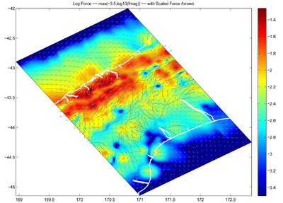
We show that the vertical derivatives of horizontal stress (VDoHS) rates, being inherently much more localized, provide substantially higher resolution surface expressions of subsurface deformation sources than either GPS velocities or GPS-derived strain rates. For our initial study region of the central South Island, our inversions reveal in detail how plate motion is partitioned.
We provide new inferences of locking depths along the Alpine Fault and show that, depending on location, 10-50% of the plate motion budget must be taken up by smaller faults. We identify potential candidates, some of which, like the main fault in the Christchurch sequence, had not been previously identified.
In addition, we see a strong signal possibly due to post-seismic deformation from the other recent Mw~7 earthquake in the region. We also produce high resolution strain rate maps and identify previously unknown extension over the Main Divide at the highest points of the Southern Alps.


