
Tales of a lake:
Glacial Evolution and Sedimentary Processes in Western Norway
By:
Nicolas Waldmann
Haifa University
| When: | Tuesday, November 27, 2012, 10:30 a.m. to 11:30 a.m. Join us for coffee beginning at 10:00 a.m. |
| Where: | Seminar Conference Room, 10100 Burnet Road, Bldg 196-ROC, Austin, Texas 78758 |
| Host: | Jamie Austin, UTIG |
Click for a Live Broadcast.
Abstract
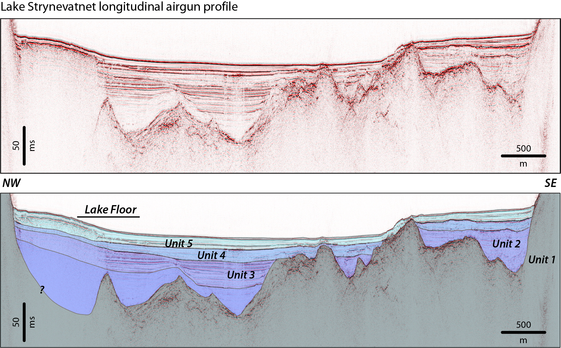
Valleys, lakes and fjords are spectacular features of the Norwegian landscape. Yet, their beauty often contrasts with the natural hazard that they represent. Three lacustrine systems in the Nordfjord region (Western Norway) have been surveyed combining simultaneously 3.5 kHz (pinger) single-channel and 1 in3 airgun multi-channel systems. Amalgamating these data with information retrieved from sediment coring provide a string tool for calibrating the geophysical information and for chronologically constrain the different units uncovered in the lake basin.
The seismostratigraphic analysis of the geophysical data is interpreted to reflect glaciomarine sedimentation during ice retreat and transition to marine and lacustrine sedimentation as glacio-isostatic rebound turned the fjord into a land-locked lake. In both the marine and lacustrine records there is evidence for mass-wasting activity in the form of rock avalanches, debris-flows and turbidites and other forms of rapidly deposited layers (RDL).
One of the thickest (>3m) recorded RDL in these lacustrine basins is the 8180-8030 cal yr BP Storegga tsunami event. Sedimentological and geochemical analyses of the Storegga RDL provide important insights into the mechanisms and environmental behavior of a lacustrine setting threaten under such geohazard.
January 15th, 1905 and September 13th, 1936 are recorded in Norwegian history as dates of occurrence of the most devastating natural hazards in modern times. During these two catastrophes, large rock-falls collapsed into the valley provoking tsunami waves as high as 74 m and killing all together more than 135 people. Evidence for these disasters appears in the seismic record as well as older unknown events preceding historical times. During the 1936 event over one million m3 of rock material collapsed into the lake from Mount Ramnefjellet, resulting in the formation of a turbidite, seiche and slide deposits that covered almost all the basin floor reaching up to 3 m thickness.
Using a physically-based mathematical model we have numerically simulated the 1936 landslide and related tsunami in order to better understand the effects of such events on a small lacustrine basin. This kind of dataset is the first in Norwegian lakes providing valuable information that can be further amalgamated with other historical, marine and terrestrial records. The geophysical data permit extending the identification of mass wasting events beyond the historical record providing a model that can be applied to comparable basins at various temporal and geographical scales.


