
Sensitivity of ice age climate to northern oceanic pathway between Pacific and Atlantic
By:
Aixue Hu
National Center for Atmospheric Research (NCAR)
| When: | Friday, September 10, 2010, 10:30 a.m. to 11:30 a.m. Join us for coffee beginning at 10:00 a.m. |
| Where: | Seminar Conference Room, 10100 Burnet Road, Bldg 196-ROC, Austin, Texas 78758 |
| Host: | Charles Jackson, UTIG |
Click for Live Broadcast
Abstract
A great challenge in understanding the paleoclimate record is identifying the causes of the abrupt climate change events recorded in the Greenland Ice Core data and the eustatic sea level oscillations of 20~30 meters occurred during last glacial period. These events cannot be solely explained by Milankovitch forcing, such as the changes of solar radiation. Evidence suggests that the variations of the oceanic meridional overturning circulation (MOC, or Thermohaline circulation, THC) may have played an essential role on these events. Here we show, using state-of-art fully coupled climate models, that the northern oceanic pathway between the Pacific and the Atlantic may have played a crucial role in these events through modulating the MOC. With this pathway open, fresher North Pacific water flows into the Arctic, subsequently into the Atlantic, affecting the upper ocean stratification there, thus the strength of the deep convection and the MOC. If this pathway is closed, the freshwater transport from the Pacific into the Atlantic would be shut off, causing a strengthening of the MOC, then a warming of the North Atlantic region. In the event of ice sheet melting, this closed pathway will keep the freshwater flux from the melting ice sheet longer in the North Atlantic, thus modulating the response of the MOC to freshwater forcing in the Atlantic, and affecting the stability of the MOC. Further, this might influence the stability of the ice age climate.
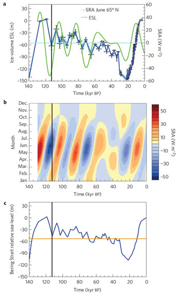
Figure at right: Sea-level and solar-radiation variations.
a, Ice-volume ESL and solar-radiation anomaly (SRA) at 65°N in June. The bars give the error range on ESL age and magnitude, and the shading provides the estimated error envelope.
b, Monthly SRA at 65°N.
c, Predicted RSL in the Bering Strait region (blue line); the orange line shows the present-day Bering Strait depth. RSL below this line indicates a subaerial Bering Strait. SRA is relative to the mean of the past 130 kyr. The vertical black line in each part indicates the ESL minima at 112 kyr BP.


